Showing posts with label Hurricane. Show all posts

Thursday, November 05, 2020

Eta - Tropical Depression Eta, Tropical Storm Eta, Hurricane Eta -- Will they be wrong AGAIN???

Editorial By: Leonard Lenny Vasbinder

November 05, 2020

UPDATED - November 06, 2020

UPDATED - November 10, 2020 (with commentary from November 08, 2020, included since my Cox internet has been mostly off the past two days)

UPDATED - November 11, 2020

(To Be Updated Daily Until Gone)

====================

Today's deals on my Amazon Store -- https://amzn.to/2QGmo2n
Thanks for shopping through my store. I do earn a very small commission on your purchases but it doesn't cost you anything extra.

=====================

Well, we now know why there was never a Greek Empire -- because they have their alphabets all screwed up.  A, B, G, D, Z, E, WTF???

Here is my next poke at the weather forecasters, who think they can predict climate change going out 10, or 100, or 1,000 years but they almost never get the 5-day forecast correct for hurricanes.  Will they prove me wrong with this one?

Here is the current 5-day forecast for Tropical Depression Eta. First, from the National Hurricane Center (NHC) and the National Oceanic And Atmospheric Administration (NOAA) and second from Weather Underground (WU).  Usually, they have the same tracking info but the past couple of storms had WU giving their own tracking information since the NHC/NOAA has been so bad, especially this year with Gulf storms.


UPDATE - November 06, 2020 -- 

The forecasters and spaghetti models have Eta going all over the place but so far, only one model has Eta coming west and making landfall on the Mississippi Gulf Coast.  All of the other models have it zig-zagging and going back to the east over the Florida peninsula.  

This one graphic from November 04, 2020, has Eta pretty much swallowing the FL peninsula. I have named this image -- Eta The Green-Blob Sea Monster.


UPDATE - November 10, 2020, at 10:00 a.m., which includes commentary from November 08, 2020.  My Cox internet has been off and on the past two days so I was not able to update this article.

Well, the forecasters have been consistent on their 5-day tracking forecast with Eta -- consistently WRONG AGAIN, and AGAIN, and AGAIN!

At least the Spaghetti Models are being honest now and admit they have no clue WTF Eta will be going. LOL  Anywhere from Tampa Bay, FL to the central Gulf Coast of Louisiana -- and everywhere in between.


These next two images are from November 08, 2020, where the so-called experts show Eta heading straight to Tampa Bay / St. Petersburg, FL.


But, don't let their November 08, 2020 tracking forecast detract from their new 5-day tracking forecast.  The November 10, 2020, 5-day tracking forecast which shows they were dismally wrong on that forecast. Scroll up a couple of images to the 5-day tracking forecast from November 08, 2020.


UPDATE November 11, 2020 --

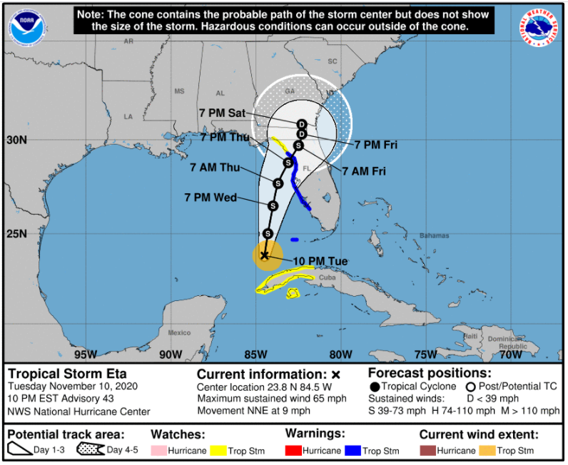
Between 10 a.m. EST on November 10, 2020 (see above two images), and 10 p.m. EST on November 10, 2020 (below two images), the so-called experts drastically changed their forecast track AGAIN!!!  Then, on November 11, 2020, at 10 a.m., they changed it yet again -- basically admitting that all of their previous forecasts were WRONG!


To be updated on November 12, 2020, or sooner if they admit they screwed up already.


Sunday, October 04, 2020

Hurricane Delta - was Potential Tropical Cyclone (PTC) 26 a/k/a PTC Delta 5-Day Forecast -- Will They Get This One Right? (Updated Daily)


Editorial By: Leonard Lenny Vasbinder

October 04, 2020

Updated - October 05, 2020

Updated - October 06, 2020

Updated - October 07, 2020

Updated - October 09, 2020

====================

Today's deals on my Amazon Store -- https://amzn.to/2QGmo2n
Thanks for shopping through my store. I do earn a very small commission on your purchases but it doesn't cost you anything extra.

=====================

So far this year, the weather forecasters have been nearly pathetic in their forecasting the tracks of tropical storms and hurricanes. They have been 100% wrong on the 5-day forecast.  They have also been mostly wrong on the 4-day and 3-day forecasts.  They have been a little more accurate on the 2-day forecast but several times, even got those wrong. 

So, how will they do with this late-season storm?  Hopefully, they will be wrong again since the local weather people are almost giddy with excitement that this one will be coming to New Orleans, Louisiana. Although the models have it going from the Texas-Mexico border to the Alabama Gulf Coast.  One model has it still in the Gulf at the 5-day mark and heading towards the Florida Gulf Coast.

Here are the spaghetti models for the 5-day forecast, dated October 04, 2020, at 8:00 p.m. EDT.

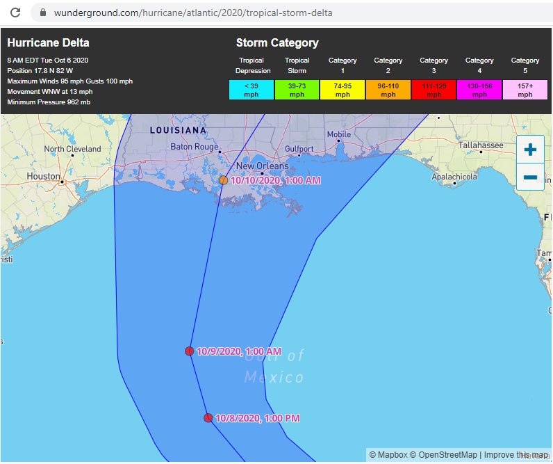
Here is the Weather Underground tracking model as of October 04, 2020, at 8:00 p.m. EDT., heading straight to New Orleans as a Category-2 on October 09, 2020, at 1:00 p.m.  The cone of uncertainty goes from the Texas-Louisiana border to the Alabama-Florida border.  Weather Underground basically takes the National Weather Service (NHC - NOAA) information and applies it to their map format.


I will be updating this article at least once a day. Now let's see if they get this one right or wrong?  If I was a betting man, I'd bet they are wrong since they are wrong 95% of the time on the 5-day forecasts concerning storms in the Gulf of Mexico.


Nine hours after their first oopsie, or 12 hours from the first 5-day forecast and they have changed things again. Basically, every time they change the forecast, they are admitting that they were wrong on the previous forecast -- right?  Here is the October 5, 2020, 8 a.m. EDT forecast map.

UPDATE October 06, 2020 -- 

While Delta is forecast to strengthen up to a Cat-4, the track now brings it over the Yucatan peninsula where it will drop down to a Cat-3, then possibly strengthen to a Cat-4 before crossing cooler Gulf waters where it is forecast to diminish to a Cat-2 and make landfall late Friday night, October 09, 2020, into early Saturday morning, October 10, 2020.  The latest track shows Delta making landfall south of Baton Rouge, Louisiana, then heading North-Northeast crossing between Baton Rouge and New Orleans.


The spaghetti models have also changed, moving Delta further west towards the Baton Rouge, LA area, with a couple of tracks showing Delta heading as far west as the Lake Charles, LA area -- which is still recovering from Cat-4 Hurrican Laura.


UPDATE October 07, 2020 --

Well, the hurricane and weather forecasters are making this too easy for me.  As I wrote about a few days ago, and many times in the past, they are WRONG 95% of the time on the 5-day tracking forecast for Gulf hurricanes.  They have been 100% WRONG this year and Hurricane Delta is another in their long list of failures.

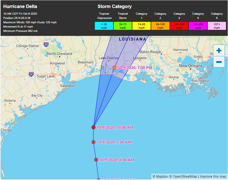
I'll be updating my article in a little while.  Just three days ago, they had Delta heading straight to New Orleans and now it is forecast to make landfall on the Gulf coast between Lake Charles and Lafayette over 150 miles to the west of their original tracking forecast.

Why don't they just admit that they cannot do 5-day forecasts instead of causing all this anxiety and panic-shopping for people?

My advice?  Just report the 5-day, 4-day, and 3-day cone without trying to give an actual track so people can do like I do and look at the actual maps, spaghetti models, etc. and make informed choices for themselves.

Compare the next three images to the images from October 04, 2020, to see just how bad they were.


UPDATE - October 09, 2020 --

They were wrong AGAIN!!!

If you look above, the October 04, 2020, 5-day spaghetti models were all wrong.  By October 06, 2020, two of the spaghetti models, the orange triangle and orange square were far more accurate than the other 15 models. By October 07, 2020, the other 15 started moving further west but still had another 50+ miles to go.

These same so-called experts who cannot get a hurricane forecast correct just 5-days out somehow think they can predict climate change 10, 20, 50, and 100 years out.  SMH!!!

Here are the latest maps.


Final Update - October 09, 2020 @ 641pm -- Delta made landfall south of Lake Charles, Louisiana, as a Category-2 and is expected to slow down to a Cat-1, then a Tropical Storm while still in Southern Louisiana. 


Friday, August 21, 2020

Just How Bad Are The 5-Day Hurricane Forecasts? (to be updated daily)

Leonard Lenny Vasbinder
August 21, 2020
Updated August 22, 2020
Updated August 22, 2020, 8 p.m. 
Updated August 23, 2020, 8 p.m.
Updated August 24, 2020, 8 p.m.

Thanks for reading my blog and following my blog and Youtube Channels. Please consider using my Amazon Store link for your Amazon shopping. I earn a very small commission from Amazon and it doesn't cost you anything extra. https://amzn.to/3cYkMcU

==============================

I've written many times over the years -- basically since Hurricane Katrina back in 2005 -- that the 5-day forecasts are almost always wrong (around 95% wrong).  The best place to go, based on the 5-day forecast, is to go to the place where they say it is going -- because it is NOT going there. :P 

Here is yesterday's 5-day forecast for TD13 (now upgraded to TS Laura) which had it close to the Florida west coast and heading towards the Pensacola-Destin area.  The next image is today's 5-day forecast for TS Laura which has it heading directly for New Orleans -- around 100 miles further west.

As of now, the best place to go is New Orleans -- well, except for the fact that New Orleans storm drainage SUCKS BIG-TIME and the streets flood when it barely sprinkles here. :P  

I know -- I live here.  

While these images are from my favorite weather website, Weather Underground, this is not to disparage them since they are merely putting up the images done by the national weather and hurricane center forecasters.


After just two days, or technically a day and a half from the first 5-day forecast on August 20, 2020, at 8 p.m., the latest 5-day forecast on August 22, 2020, at 11 a.m. shows TS Laura heading about 100 miles west of New Orleans, LA, even west of Morgan City, LA.  Two days ago, the 5-day forecast had the storm skirting the west coast of Florida and hitting the Florida panhandle between Pensacola and Destin.


Update - August 22, 2020, 8 p.m. -- 

You really can't make this up.  

For the past two days, I've been mainly writing about TD13-TS Laura because TD14-TS Marco was heading west of Houston and TS Laura was heading more towards New Orleans but even west of New Orleans as of earlier today.

As of the 7 p.m. to 8 p.m. updates, NOW BOTH storms are heading directly to New Orleans.  

Now, TS Marco is forecast to hit New Orleans on Monday, August 24, 2020, late p.m. and TS Laura is forecast to hit New Orleans on Wednesday, August 26, 2020, late p.m.

The forecasters should really be embarrassed about just how bad they have mucked these forecasts up!

Here is TS Marco's path as of 10 a.m. on August 22, 2020.  The next image is TS Marco's path as of 7 p.m. on August 22, 2020.


Update - August 23, 2020, 8 p.m.

Well, the good news for New Orleans is the forecasters and politicians were horribly wrong no matter how hard they fearmongered to the television audience.

From 8 p.m. on August 22, 2020, until now, you can see that TS Laura has moved a couple hundred more miles to the west. Instead of the above forecasted direct hit on New Orleans, TS Laura is now forecast to make landfall near the LA-TX border -- but it's still three days away so who knows how many more forecast changes will happen.


As far as TS Marco, while the politicians and weather news wanted it to also hit New Orleans -- makes for better ratings and a reason for pols to spend money -- TS Marco is heading further away from New Orleans also.


Update - August 24, 2020, 8 p.m. 

Well, TS Marco was a complete DUD!  At least as far as New Orleans and the LA Gulf Coast are concerned.  The FL panhandle did get a lot of rain and thunderstorms but there hasn't been hardly any rain in New Orleans today and not much wind either -- well, except for the wind from the blowhard politicians!  While Walmart and most other businesses remained open, the local governments shut down!  Why?  Because they still get paid whether they are open or self-shutdown.

Here is the August 24, 2020, 6 p.m. track for TS Marco.  It supposedly made "landfall" at the mouth of the Mississippi River as a tropical storm and is dying quickly but they forecasters are still trying to squeeze in one last gasp of fearmongering by having the Tropical Depression (winds less than 39 mph) head up towards the NOLA metro area.


TS Laura is supposed to turn into a Cat-1 hurricane by August 26, 2020, and then turn into a Cat-2 hurricane before making landfall on August 27, 2020, early a.m.  

We'll see!


I'll continue to update for the next couple of days but my closing below will likely stay the same.

In closing, you can see just how inaccurate even a 5-day forecast is, yet these same so-called experts and liberal-democrat politicians keep trying to predict the weather for decades and centuries from now -- and they'll likely be wrong about those predictions as well.


Related Posts with Thumbnails

World Flag Counter added 04/14/2010 and U.S. Flag added 04/26/2010, so the numbers are WAY low.

free counters Free counters!

Followers