Editorial By: Leonard Lenny Vasbinder
October 04, 2020
Updated - October 05, 2020
Updated - October 06, 2020
Updated - October 07, 2020
Updated - October 09, 2020
====================
Thanks for shopping through my store. I do earn a very small commission on your purchases but it doesn't cost you anything extra.
=====================
So far this year, the weather forecasters have been nearly pathetic in their forecasting the tracks of tropical storms and hurricanes. They have been 100% wrong on the 5-day forecast. They have also been mostly wrong on the 4-day and 3-day forecasts. They have been a little more accurate on the 2-day forecast but several times, even got those wrong.
So, how will they do with this late-season storm? Hopefully, they will be wrong again since the local weather people are almost giddy with excitement that this one will be coming to New Orleans, Louisiana. Although the models have it going from the Texas-Mexico border to the Alabama Gulf Coast. One model has it still in the Gulf at the 5-day mark and heading towards the Florida Gulf Coast.
Here are the spaghetti models for the 5-day forecast, dated October 04, 2020, at 8:00 p.m. EDT.
Here is the Weather Underground tracking model as of October 04, 2020, at 8:00 p.m. EDT., heading straight to New Orleans as a Category-2 on October 09, 2020, at 1:00 p.m. The cone of uncertainty goes from the Texas-Louisiana border to the Alabama-Florida border. Weather Underground basically takes the National Weather Service (NHC - NOAA) information and applies it to their map format.
I will be updating this article at least once a day. Now let's see if they get this one right or wrong? If I was a betting man, I'd bet they are wrong since they are wrong 95% of the time on the 5-day forecasts concerning storms in the Gulf of Mexico.
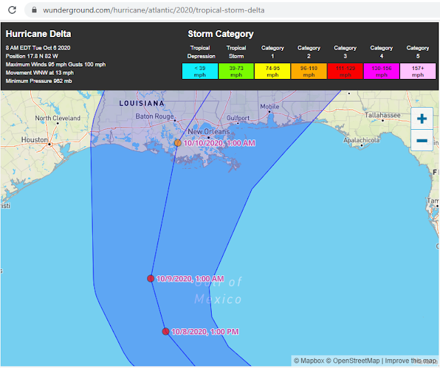
Nine hours after their first oopsie, or 12 hours from the first 5-day forecast and they have changed things again. Basically, every time they change the forecast, they are admitting that they were wrong on the previous forecast -- right? Here is the October 5, 2020, 8 a.m. EDT forecast map.
UPDATE October 06, 2020 --
While Delta is forecast to strengthen up to a Cat-4, the track now brings it over the Yucatan peninsula where it will drop down to a Cat-3, then possibly strengthen to a Cat-4 before crossing cooler Gulf waters where it is forecast to diminish to a Cat-2 and make landfall late Friday night, October 09, 2020, into early Saturday morning, October 10, 2020. The latest track shows Delta making landfall south of Baton Rouge, Louisiana, then heading North-Northeast crossing between Baton Rouge and New Orleans.
The spaghetti models have also changed, moving Delta further west towards the Baton Rouge, LA area, with a couple of tracks showing Delta heading as far west as the Lake Charles, LA area -- which is still recovering from Cat-4 Hurrican Laura.

UPDATE October 07, 2020 --
Well, the hurricane and weather forecasters are making this too easy for me. As I wrote about a few days ago, and many times in the past, they are WRONG 95% of the time on the 5-day tracking forecast for Gulf hurricanes. They have been 100% WRONG this year and Hurricane Delta is another in their long list of failures.
I'll be updating my article in a little while. Just three days ago, they had Delta heading straight to New Orleans and now it is forecast to make landfall on the Gulf coast between Lake Charles and Lafayette over 150 miles to the west of their original tracking forecast.
Why don't they just admit that they cannot do 5-day forecasts instead of causing all this anxiety and panic-shopping for people?
My advice? Just report the 5-day, 4-day, and 3-day cone without trying to give an actual track so people can do like I do and look at the actual maps, spaghetti models, etc. and make informed choices for themselves.
Compare the next three images to the images from October 04, 2020, to see just how bad they were.
UPDATE - October 09, 2020 --
They were wrong AGAIN!!!
If you look above, the October 04, 2020, 5-day spaghetti models were all wrong. By October 06, 2020, two of the spaghetti models, the orange triangle and orange square were far more accurate than the other 15 models. By October 07, 2020, the other 15 started moving further west but still had another 50+ miles to go.
These same so-called experts who cannot get a hurricane forecast correct just 5-days out somehow think they can predict climate change 10, 20, 50, and 100 years out. SMH!!!
Here are the latest maps.
Final Update - October 09, 2020 @ 641pm -- Delta made landfall south of Lake Charles, Louisiana, as a Category-2 and is expected to slow down to a Cat-1, then a Tropical Storm while still in Southern Louisiana.


No comments:
Post a Comment