By: Leonard Lenny Vasbinder
October 25, 2020, at 5 p.m.
UPDATED October 25, 2020, at 11 p.m.
UPDATED October 26, 2020, at 9:30 a.m.
UPDATED - Tuesday, October 27, 2020, at 9:00 A.M
UPDATED - Tuesday, October 27, 2020, at 11:00 P.M.
UPDATED - Wednesday, October 28, 2020, at 9:00 A.M.
(To be updated at least daily until landfall.)
===============
Holiday Deals on my Amazon Store -- https://amzn.to/34b41Ke
Thanks for shopping through my link. I do earn a very small commission but it doesn't cost you anything extra.
===============
***** Zeta was ONLY forecast to be a tropical storm BUT the forecasters did seem to get that wrong. As of the Wednesday morning update, they now have Zeta as a Cat-1 and becoming a weak Cat-2 by 1 p.m. on Wednesday, October 28, 2020. *****
Will the forecasters fail again on the 5-day forecast, which is actually only a 4-day forecast as of the beginning of this report.
The first image is from the National Oceanic & Atmospheric Administration (NOAA), National Weather Services (NWS), and the National Hurricane Center (NHC) website. https://www.nhc.noaa.gov/refresh/graphics_at3+shtml/212827.shtml?cone#contents
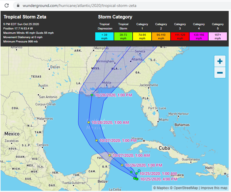
The second image is from Weather Underground which is basically the same info as above but the map is more interactive and can be zoomed in, etc. https://www.wunderground.com/hurricane/atlantic/2020/tropical-storm-zeta
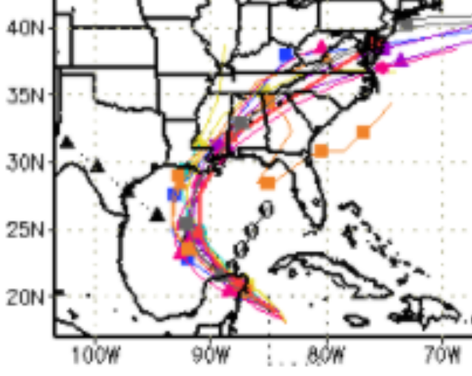
The third image is from the South Florida Water Management District for the Spaghetti Maps. https://www.sfwmd.gov/weather-radar/hurricane-model-plots The fourth image is ZOOMED in on the third image.
Brevard Times also updates their story with most of the below information. http://www.brevardtimes.com/2020/10/noaa-tropical-storm-zeta-track-spaghetti-models/
The spaghetti maps have it hitting anywhere from the Texas/Louisiana (TX/LA) border to Alabama's (AL) coastline. Let's see how they do for this Gulf storm. The forecasters have been 100% WRONG so far this year on Gulf of Mexico storms -- at least for the 5-day forecast. They usually get better on the 3-day and 2-day forecasts but have been pretty bad on those as well.
It seems like almost every storm starts out with a track heading to New Orleans since that seems to get the best fearmonger ratings.
UPDATE - October 25, 2020, at 10:00 PM CST --
Well, it's just six hours later and the forecast has changed. Not by much but TS Zeta is now forecast to make landfall further west of New Orleans. At 5:00 PM CST, Zeta was forecast to make landfall almost directly below New Orleans.
Here is a ZOOM of the 5 PM map followed by a ZOOM of the 11 PM map. The 5 PM map shows the track skirting the eastern edge of Lake Pontchartrain while the 11 PM map has the track skirting the western edge of Lake Pontchartrain -- a distance of almost 40 miles.
UPDATE - Monday, October 26, 2020, at 9:30 a.m.
From 5 p.m. on October 25, 2020, until 8 a.m. on October 26, 2020, the forecasters have changed the track in a big way two times. As noted above, they moved the track from the east side of Lake Pontchartrain to the west side of Lake Pontchartrain, and now, as of 8 a.m. on Monday, they have moved the track back to the east side of Lake Pontchartrain but even further east according to the Weather Underground track which has the track skirting the mouth of the Mississippi River and then making landfall on the Mississippi coast. The Spaghetti Maps have also shifted to the east.
See maps and ZOOM images below.

UPDATE - Tuesday, October 27, 2020, at 9:00 A.M --
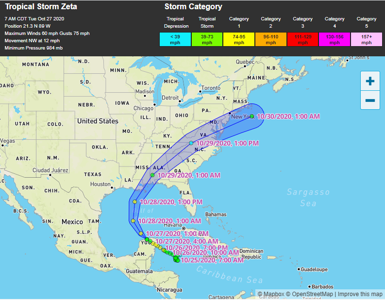
This morning updates, according to the NOAA National Hurricane Center have Zeta on a track to make landfall in the South Louisiana Gulf Coast, SSE of New Orleans, then tracking to the LA/MS border. Weather Underground (WU), which in the past has followed along with the NOAA National Hurricane Center, has veered from the course and has been projecting its own path for this storm. WU has Zeta making landfall closer to the mouth of the Mississippi River, crossing Port Sulphur, then heading to the MS Gulf Coast, making landfall again just east of Gulfport, MS, around 80 miles east of New Orleans.
The spaghetti maps aren't really relevant any longer and they have all tightened up on the Eastern New Orleans to Mississippi Gulf Coast area. Two of the tracks have Zeta heading further west towards the Baton Rouge, LA area.
UPDATE Tuesday, October 27, 2020, at 11 p.m. --
Zeta is still forecast to come onshore south of New Orleans but heading in a Northwest trajectory so Zeta is tracking towards Slidell to the Mississippi Gulf Coast for its second landfall.
Maybe, just maybe, they're getting this one right after dismal failures on the 5-day forecasts for the previous Gulf hurricanes this year (was it six or seven?)
UPDATE - Wednesday, October 28, 2020, at 9:00 A.M. --
Well, there's an old saying that even a blind squirrel finds a nut once in a while and it looks like the forecasters finally got a 5-day forecast pretty close. Zeta isn't making a direct hit on New Orleans but is skirting just to the east according to the NOAA National Hurricane Center and even further east according to Weather Underground (WU).
Usually, WU mirrors what the NOAA-NHC is putting out but for Zeta, WU had slightly different tracking information with almost every updated forecast. We will see in a few hours which track was correct.
Next UPDATE planned for Wednesday, October 28, 2020, PM after actual landfall --


No comments:
Post a Comment